
Key Physical Features of the Tahoe Watershed
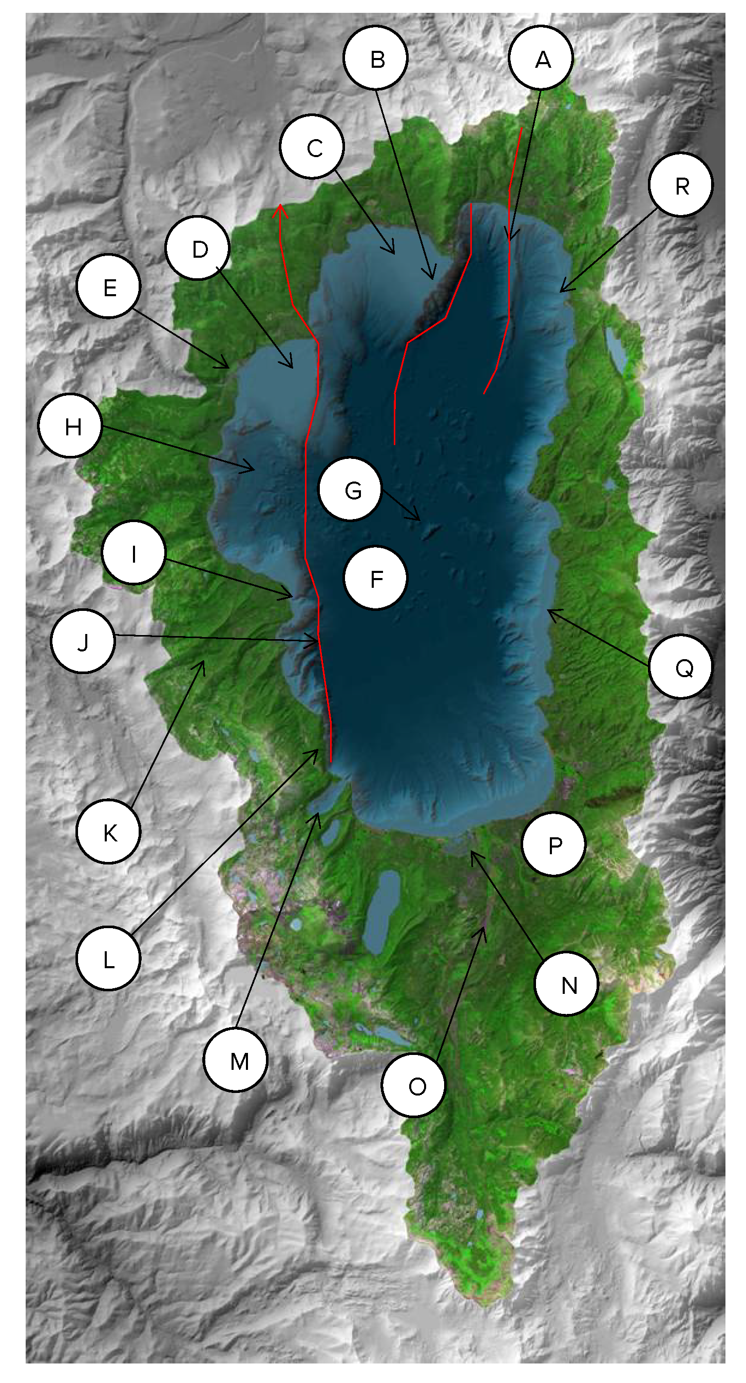
A. Incline Village Fault: Heading south past the fault is the deepest part of the lake at 1,645 feet. You will notice giant ripple marks, some with 50 meters between them.
B. Stateline Fault: Amazing snorkeling and a ~1,400-foot underwater cliff.
C. Kings Beach Shelf: Underwater shallow shelf near Kings Beach
D. Tahoe City shelf: Remaining shelf after landslide. May not have slid due to being composed of volcanic material instead of sediment, although could possibly be disrupted in a large (7.0 magnitude) earthquake.
E. Truckee River: Tahoe’s only outlet, 63 streams and rivers flow into the lake.
F. Sediment at the bottom of the lake: The bottom is mostly flat but after years of sedimentation the layer of sediment that makes up the bottom is estimated to be almost double the depth of the water level.
G. Underwater blocks: The largest block from the landslide is 1 km across. The blocks are composed of consolidated sediment.
H. McKinney Bay underwater landslide: The McKinney Bay underwater landslide occurred somewhere between 12,000 and 21,000 years ago. A 7.0 magnitude earthquake is thought to have caused this land area to collapse. The displacement would have caused a large tsunami with waves as high as 100 to 300 feet tall. Seiche waves (where water would slosh back and forth) are estimated to have lasted for 24 hours following the initial tsunami.
I. General Creek sediment plume: Clearly shows sediment coming from stream into lake and fault scarp cutting through it. Sediment plume to the left does not have fault cutting through it indicating a younger age.
J. West Tahoe Fault: Runs the whole west side of the lake. See evidence of fault “slippage” or movement. This distinct fault through the sediment is evidence that the fault ruptured relatively recently as the fault cuts through it.
K. Glacially carved valleys: Glaciers came through here in the Tahoe (100,000 years ago) and Tioga (50,000 years ago) ice ages. The land pushed by a glacier and deposited is called a “moraine” which you can see prominently above General Creek sediment plume.
L. Steep area of D. L. Bliss State Park: great hiking spot.
M. Emerald Bay: Just south of Emerald Bay is Cascade Lake, the larger lake is Fallen Leaf Lake. The ridge on the south side of Fallen Leaf Lake is Angora Ridge, the site of the 2007 fire that burned 260 homes. Observe that these are also glacially formed, and moraines are present here as well.
N. Tahoe Keys: former wetland developed in the 1960’s. Loss of filtering and warmer water creates favorable habitat for invasive species, some of which may have been dropped in lake from fish tanks.
O. Upper Truckee River: Responsible for approximately one third of the inflow to the lake.
P. South Lake Tahoe: Airport, Mackinaw/Lake Trout fishing just offshore. The fish also spawn here as they are exposed to the photic zone but are still protected by the erosional feature of the shelf. Sediment shelf here is similar to the west shore pre- landslide.
Q. Continue along east shore. Point out Cave Rock: the remnant of a volcanic plug considered to be sacred by the Washoe Tribe.
R. Point out Sand Harbor and Mount Rose as you head back to Incline Village